The Poremsky Family
Day Trips
Day Trips in East Tennessee
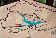
Maps: Tenn and VA and Waterfalls
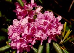
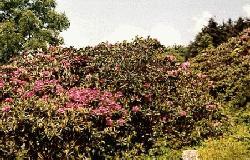
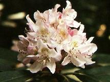
Roan Mountain State Park - 600 acre Rhododendron Garden
US 19E South of Johnson City, TN on TN/NC state line, along the Appalachian Trail. Gardens are at the top of the mountain, off TN 143 at Carver's Gap. Gardens have some paved trails & handicap-accessible areas. Elevation: 6267 feet.
In bloom about mid-June. NC side of gardens charge a per car entry fee (was $3.00 at the time this page was published).
Shown on Map shaded green (for state parks).
Bay's Mountain Park, Kingsport TN
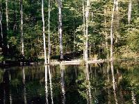
 Natural trail around lake (2 miles, easy)
and several ridge trails (2.5 to 11 miles, easy to moderate). Paved trails around animal
cages.
Natural trail around lake (2 miles, easy)
and several ridge trails (2.5 to 11 miles, easy to moderate). Paved trails around animal
cages.
Park includes nature center and planetarium.
Admission charged ($3.00 per car at the time of publishing). Additional fees may be required for planetarium shows & boat rides.
Official Bay's Mountain website.
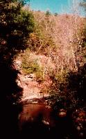
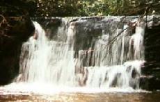
Laurel Fork Falls, Dennis Cove Rec. Area, Hampton, TN
45 - 55 feet high
Take Dennis Cove Road out of Hampton, limited parking at trail head (Appalachian Trail). Easy 1 mile hike most of the way. Near the falls you turn off the main trail & go down a steep 3/10 mile trail.
It is also accessible from a second, longer trail, parking area along 321. This longer trail is said to be less steep. There are several smaller falls in the Dennis Cove area also.
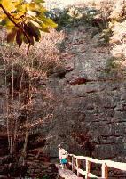
Canyon walls are 150 feet high in
places.
Gorge walls along Laurel Creek are popular with rappelers.
Spivey Falls, off 19W south of Erwin, TN
25 - 35 foot drop, then cascades another 15 -25 feet
Limited parking along 19W. On privately-held land (with a privately maintained trail), short hike (1/4 mile) down to stream. Permission of land owner not required before visiting falls.
Backbone Mt., along TN 133
- 35 - 45 foot falls. Falls may be sparse during dry weather.
North of Shady Valley, near VA state line. Popular practice area for climbers.
Falls is across the road from the
main area. Trail circles back to the road. The 'upper' trail is narrow with steep drop
offs. Use the lower trail if accompanied by young children.
![]()
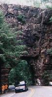
![]() Narrow tunnel cut through end of rock for road. A trail runs across the ridge line.
Climbers frequently climb to the left of the tunnel.
Narrow tunnel cut through end of rock for road. A trail runs across the ridge line.
Climbers frequently climb to the left of the tunnel.
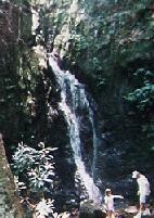
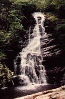
Elk Falls (aka Big Falls) off US 19E, near Elk Park, NC
- 61 feet high falls
 Okay, so this
isn't exactly in Tennessee -- but it's so close. You turn left off 19E, 9/10 of a mile
across the state line. Travel backroads for about another 5 miles and you're at the head
of the falls. A short trail takes you to a large flat rock at the top of the falls,
continue on the trail to the pool at the bottom of the falls.
Okay, so this
isn't exactly in Tennessee -- but it's so close. You turn left off 19E, 9/10 of a mile
across the state line. Travel backroads for about another 5 miles and you're at the head
of the falls. A short trail takes you to a large flat rock at the top of the falls,
continue on the trail to the pool at the bottom of the falls.
 For the really
energetic, it's about 1/2 mile hike to the Tennessee state line.
For the really
energetic, it's about 1/2 mile hike to the Tennessee state line.
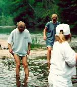
Large deep pool below falls, popular for swimming in the summer. Creek above the falls is flat, wide, shallow and slow - perfect for kids & non-swimmers to splash in.
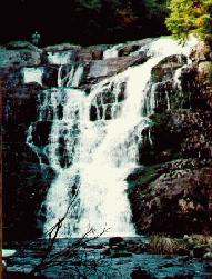
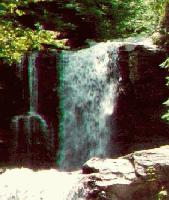
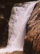
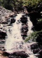
Red Fork Falls, Unaka Mt. Wilderness, near Limestone Cove, TN
 Long cascading falls. Easy hike to top
of falls area but very steep climb to bottom of falls. Several people have been killed
falling from top of falls. Not recommended for children. The rocks are very slippery -- I
found this out the hard way, fortunately I was at the bottom of the falls and only
suffered bruises.
Long cascading falls. Easy hike to top
of falls area but very steep climb to bottom of falls. Several people have been killed
falling from top of falls. Not recommended for children. The rocks are very slippery -- I
found this out the hard way, fortunately I was at the bottom of the falls and only
suffered bruises.
There are two or more long cascades and several small ones along the trail. Just downstream from the main falls is a shorter cascade and some more are below that, but getting to them is difficult. (Getting back up is not much fun either.) The trail runs to the right of the falls (looking at the pictures) and is about as steep as the falls.
"Beauty Spot" an overlook area at the top of the mountain, with a wonderful 360º view of North Carolina and Tennessee is a few miles away over forest service roads. (The road is usually suitable for cars to travel on.) The Appalachian Trail passes through Beauty Spot.
See map. Beauty Spot is along NC\TN border, Red Fork Falls to north east along Red Fork Rd.
![]() smaller falls upstream of main falls
smaller falls upstream of main falls
smaller falls downstream ![]()
(These pictures are not any where near "scale". Red Fork Falls is at least twice are high as the smaller ones.)
Buffalo Mountain Park, Johnson City, TN
This city owned park is on the south side of Johnson City.
We started at the parking area near Huckleberry Knob, elevation 2500 feet. Then continued up the trail towards Fork Knob and Tip Top, elevation 3300 feet. The trail is has a fairly low grade, surprising, since we climbed 800 feet. It follows the side of the mountain most of the way. It is narrow and a very steep drop should you loose your footing.
From Tip Top, you can almost see Kingsport, 20-some miles away. On our way back, we decided to take the shorter trail, past Lady Slipper Loop. It was steep and we were glad we were going down, not up.
Area Day Trips
Blue Ridge Parkway
Other Places